GeoServer XXE Vulnerability Exploitation (CVE-2025-58360)

XML External Entity (XXE)
Unauthenticated File Access
Critical Severity
Overview
The incident centers on an unauthenticated XML External Entity (XXE) vulnerability in OSGeo GeoServer, an open-source platform for publishing and sharing geospatial data (WMS services). The flaw is triggered in the "/geoserver/wms" GetMap endpoint, where crafted XML input isn't safely validated, allowing attackers to define external entities that can access files or be abused for network probing.
This vulnerability poses a significant risk to U.S. civilian agencies and has been added to CISA's Known Exploited Vulnerabilities (KEV) catalog, with active exploitation confirmed in the wild.
Technical Specifications
| Attribute | Details |
|---|---|
| CVE ID | CVE-2025-58360 |
| Vulnerability Type | XML External Entity (XXE) Reference (CWE-611) |
| CVSS Score | 9.8 (Critical) |
| Affected Product | OSGeo GeoServer |
| Affected Versions | Prior to 2.25.6; 2.26.0 through 2.26.1 |
| Patched Versions | 2.25.6, 2.26.2, 2.27.0, 2.28.0, 2.28.1 |
| Attack Vector | Network (unauthenticated) |
| Authentication | None required |
| Exploitability | Active exploitation confirmed |
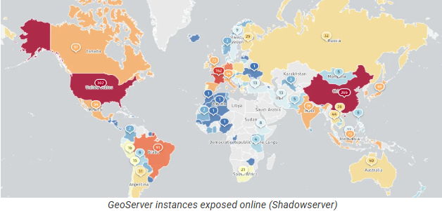
| Exposed Instances | Over 14,000 GeoServer instances exposed online |
| CISA Deadline | Federal agencies must patch by January 1, 2026 (BOD 22-01) |
Technical Details
Vulnerability Classification
- CVE: CVE-2025-58360
- Vulnerability type: Improper Restriction of XML External Entity (XXE) Reference (CWE-611)
Affected Versions
- GeoServer versions prior to 2.25.6
- Versions 2.26.0 through 2.26.1
Patched Versions
Fixed in:
- 2.25.6
- 2.26.2
- 2.27.0
- 2.28.0
- 2.28.1
Exploit Vectors
The vulnerability enables three primary attack vectors:
-
Arbitrary File Access via crafted XML
- Read sensitive files on the server
- Access configuration files, credentials, etc.
-
Server-Side Request Forgery (SSRF)
- Probe internal networks
- Map infrastructure
- Access internal services
-
Denial of Service (DoS)
- Exhaust resources
- Cause service disruption
Attack Scenario
-
Target Identification: A remote attacker identifies an internet-facing GeoServer instance (over 14,000 exposed online).
-
Malicious Request: Attacker sends a malicious XML request to the GeoServer
/geoserver/wmsGetMap endpoint. -
XXE Processing: Because GeoServer did not properly restrict or sanitize XML external entity references, the server processes the external entity.
-
Exploitation: This allows the attacker, without authentication, to:
- Access sensitive files on the server (e.g., system configs or credentials)
- Trigger server-side requests to internal systems (SSRF)
- Potentially cause resource exhaustion (DoS)
-
Scale: Automated scanners and exploit tooling can target exposed internet-facing GeoServer instances at scale.
Impact Assessment
- Sensitive information on affected servers may be accessed
- Configuration files
- Credentials
- System files
- Geospatial data
- Internal networks could be mapped via SSRF
- Discovery of internal services
- Reconnaissance for further attacks
- DoS impacts availability
- Resource exhaustion
- Service degradation or complete outage
- CISA sees significant risk to U.S. civilian agencies
- Mandates patching by January 1, 2026
- Part of Binding Operational Directive (BOD) 22-01
- Over 14,000 GeoServer instances are exposed online
- Increasing attack surface
- Global reach of vulnerable systems
Mitigations
🔄 Apply Vendor Patches (CRITICAL)
Upgrade to a fixed GeoServer version:
- 2.25.6+ (for 2.25.x series)
- 2.26.2+ (for 2.26.x series)
- 2.27.0+ (for 2.27.x series)
- 2.28.0 or 2.28.1 (for 2.28.x series)
Federal Agency Requirement
U.S. Federal civilian agencies must patch by January 1, 2026 per CISA BOD 22-01.
🔒 Restrict Access
- Limit exposure of the
/geoserver/wmsendpoint via:- Firewall rules
- Network access controls
- VPN requirements
- Do not expose GeoServer directly to the internet unless absolutely necessary
📊 Monitor Logs
- Watch for:
- Unusual XML payloads
- External entity references in requests
- SSRF patterns (internal IP access attempts)
- Unexpected file access
- DoS indicators (resource exhaustion)
🏗️ Harden XML Parsers and Services
- Disable external entity processing in XML parsers
- Implement strict XML validation
- Use safe XML parsing libraries
- Apply principle of least privilege to XML processing
🌐 Network Segmentation
- Isolate GeoServer instances from sensitive internal networks
- Implement network segmentation
- Restrict outbound connections from GeoServer
- Limit access to internal resources
🔍 Detection & Response
Indicators of Compromise (IoCs)
- Unusual XML requests to
/geoserver/wms - Requests containing external entity definitions
- Access to unexpected file paths
- Outbound connections to internal IPs
- Resource exhaustion patterns
Response Actions
If exploitation is suspected:
- Isolate affected systems immediately
- Review logs for evidence of file access or SSRF
- Check for unauthorized data exfiltration
- Assess what internal systems may have been probed
- Reset credentials that may have been exposed
- Conduct forensic analysis
Resources & References
Official Advisories & CISA
Vulnerability Details & Analysis
Detection Guidance
Monitor for suspicious XML patterns in /geoserver/wms requests:
- Look for
<!ENTITYdeclarations - External entity references (e.g.,
file://,http://,ftp://) - Requests attempting to access system files (
/etc/passwd,C:\Windows\win.ini) - SSRF patterns targeting internal IP ranges (10.x.x.x, 192.168.x.x, 172.16-31.x.x)
Log Analysis:
Check GeoServer logs for:
- Unusual GetMap requests
- XML parsing errors
- File access exceptions
- Outbound connection attempts to internal IPs